
Joshimath under Strain: A Scientist’s View Point (Part-2)
(The first part of this article published last month, elaborated on all plausible issues involved in the problems observed at Joshimath (read “Joshimath under Strain, A Scientist’s View Point (Part-1)” https://articles.thecounterviews.com/articles/joshimath-under-strain-a-scientist-view-point-part-1/). Thereafter, the author of this article, a scientist himself, visited the affected areas to have own unbiased opinion based on evidence present. This article is the outcome of that visit).
Brief Overview
Joshimath is located on the northern slope of the Auli mountain that ends downhill 1.5 – 2 Km into the Alakhnanda/Dhauliganga river. Landscape of the township houses two important religico-historic monuments of the Shiva and Narsingh temples around which the township has come up. It attracts large numbers of Hindu pilgrims and devotees, also proceeding to Badrinath temple. Some parts of the township are on mild to moderate slopes where some are very steep, ranging upto ~75 deg. It is also the first major township bordering China hence, accommodates a reasonable garrison of the military too. This part of the Himalayas contains some sacred temples like Kedarnath and Badrinath and also has peaks like Nanda Devi. Indian govt efforts are on to connect it with rail but presently only state highway connects it with Haridwar/Dehradun from where road journeys of 8-12 hrs are made on the road that is vulnerable to frequent landslides.

Joshimath municipal corporation is subdivided in to 9 wards altogether having approx. 4000 families; ward-1 (Gandhinagar) having maximum of 715 families and ward-5 Manoharbag having minimum 253 families. However, the central part of Joshimath is full of hotels, guest houses, home stay and paying guests at every nook and corner. It is unfortunate that no construction guidelines have been followed in the construction of the dwelling units in this highly seismic zone (zone-5) of the state. Neither there is adequate depth of the pillars nor any norm/standards in the strength have been ensured. Seldom anyone has taken engineering clearance of the constructions by the municipal corporation. Hence, capacity of these buildings to withstand the stress & strain of the high seismic zone and unstable surface is highly questionable (read “Increasingly unstable Himalayas”, https://articles.thecounterviews.com/articles/increasingly-unstable-himalayas/).

Problems at Joshimath
Entire Chamoli district is in zone-5 of earthquake. In late December 2022, a major disaster hit the township causing cracks in hundreds of dwellings that drew the world media with headlines of “Joshimath is sinking”. Just a month in the natural disaster of soil subsidence and slides, Joshimath has gone off the radar of the national and international media. Almost all major media houses came and have gone back. The local municipal corporation has performed exceptionally well to come to the rescue and help of the affected population. Nearly 900 families have been evacuated out of the endangered dwellings to safer makeshift shelters of unaffected schools, public places, Garhwal Mandal Vikas Nigam (GMVN) accommodations and so on. Some have also willingly shifted out to other towns for which the govt will reimburse the rentals. In short, although the lives and livelihood of the affected people were thrown out of gear, The State administration has tried their best to apply healing touches (read ‘जोशीमठ भू-धसान के मानवीय पहलू’, https://articles.thecounterviews.com/articles/joshimath-sinking-disaster/). All affected, are trying to reconcile to the fact that some parts of Joshimath have become uninhabitable. Ward wise major impacts of the recent problems have been shown in the sketch below:-

Very few are aware of the complex issues in play at Joshimath. Teams of scientists came from various parts of India to analyse the issues. If the previous reports by Mishra Committee in 1977, Wadia Instt of Himalayan Geology and IIT Roorkee report of 2011 are to go by, it could be the land subsidence caused by uncontrolled proliferation, unplanned, improper dwelling constructions that triggered the problems earlier and now too (read ‘Joshimath under Strain, A Scientist’s View Point (Part-1)’, https://articles.thecounterviews.com/articles/joshimath-under-strain-a-scientist-view-point-part-1/). However, there could be more to the issues than that meet the eyes.
Recently, a larger number of independent scientific teams have been pressed into fact-finding. These include National Disaster Management Authority (NDMA), National Institute of Disaster Management, Geological Survey of India (GSI), Earth Science & Earthquake & Natural Disaster Deptts of IIT Roorkee, Wadia Institute of Himalayan Geology, Dehradun and Central Building Research Institute, among some others. It is hoped that these teams would independently look at all issues and submit their comprehensive reports that would be deliberated all together before reaching the conclusion and implementing the recommendations. On the surface however, there are number of tell-tale signs of the disaster as mentioned below.
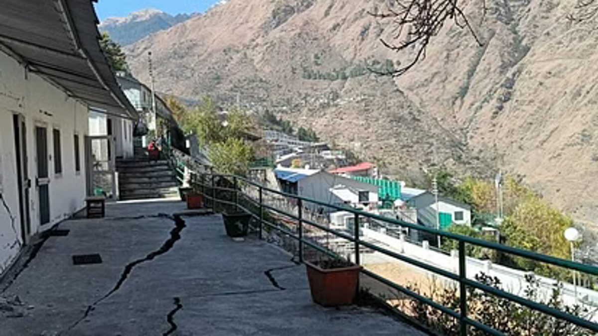
Almost entire Joshimath township is located at the northern slope of Auli Mountain having varying slope gradients at different points. The slope ranges anything from 30 deg to 75 deg from horizon at different places. While the Jyotirling and Narsingh temples are among the oldest constructions on the original moderate slope, larger parts of Ward-5 (Manoharbag) is believed to have come up on a nallah that was accidentally filled with the landslide debris of mid-18th century and also by mud-fillings. It is quite possible for the artificial surface over the nallah and adjoining areas to have undergone subsidence whereas the constructions showing cracks on the higher sloped surfaces may be showing tendencies of land-sliding and cracks as shown in the figure below: -

The author visited some of the dwellings in ward-4 that developed cracks. This ward has slope gradients varying from 45 deg to near 75 deg at some places. It is evident that there are both push and pull factors involved in the cracks on walls and the floors. The wall of a house in the photograph below has slight bulge of push of the mud/soil in contact on the other side of the wall as if it is sliding down. Although such cracks can be seen following moderate earthquakes/tremors, but these cracks are reported to have developed in the absence of such tremors. These are clearly the signs of overpressure. On the other hand, there are also gaping cracks that in all likelihood, is the result of sub-soil pulls. In some of the areas, the sub-soil pulls are evident in the form of gaping cracks.

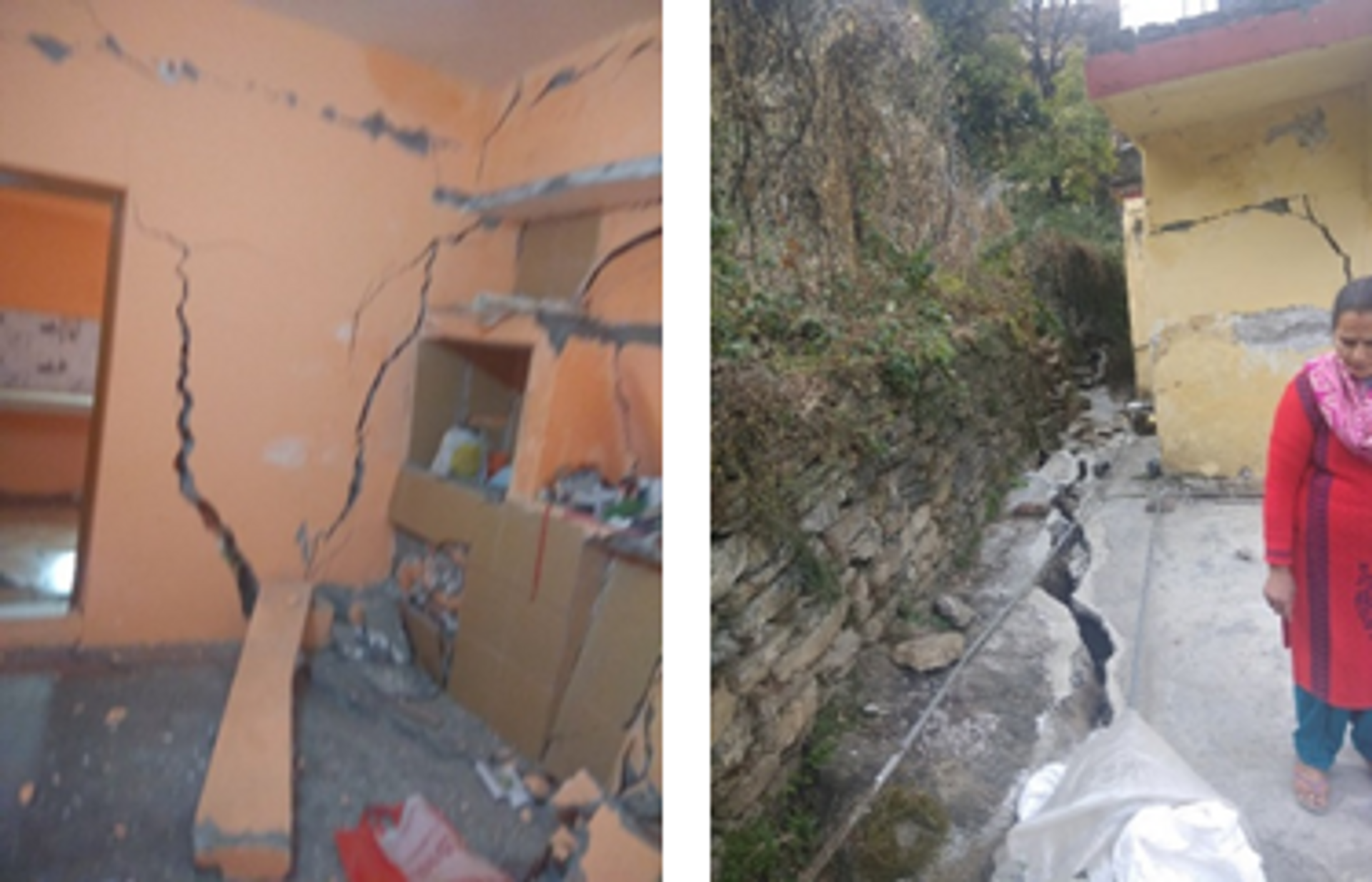
There are also smaller patches in this area where the surfaces have caved in to the gapping cracks underneath. This cannot be termed as subsidence or sinking. On the other hand, there are some areas in ward-5 where other than the push & pull cracks, sinking of land along with overhead dwellings showing signs of land subsidence were reported by various media. However, author of this article failed to observe any area of Joshimath that could be termed purely as sinking as a result of subsidence. Wherever small patches of ground cave-in were reported, that met more of pull-cracks as a causative factor in which those patches of road/path/structures caved in. One must appreciate that subsidence of land is observed when those stretches of affected areas sink enmass with the over structures. Except the ISRO report, there is no other agency to suggest that Joshimath is sinking thru’ subsidence of its’ territories. Questions on the ISRO report are very logical which claimed 5.6 mm of subsidence on a city raised on varying gradients of slopes of nearly a kilometre. Wisely, the report was withdrawn quickly. It is also worth mentioning here that the cracks observed in Rudra-prayag and Karna-prayag too were in the steep gradient zones on the bank of Alakhananda river. There too, drainage systems are deficient. This is also a warning for the entire world to be cautious in having dense dwellings on steep slopes.

Even though several teams of scientists are looking into the cause of the present crisis in Joshimath, a small section of people is already trying to raise a narrative of the 11.7 km x 4.8m long Hydro-power tunnel being responsible. There are already slogans of ‘NTPC Go Back’ on the walls of Joshimath. Groups having links with Communists and leftist movements are already in dis-information campaigns since 2015 to malign the Tapovan-Vishnugadh Hydro-power project on various pretexts (read, ‘उत्तराखण्ड में आपदा कौन है जिम्मेदार ?’, https://bit.ly/3qyeF6y). They also want the govt to stop all infrastructure (road & rail) projects of developments of the region. It is a fact that this project has been having various setbacks and issues right from 2009 (read ‘Tapovan Vishnugadh HPP: delays, damages and destructions’, https://sandrp.in/2021/02/20/tapovan-vishnugad-hpp-delays-damages-and-destructions/). Following the recent problems, there are also Human and humanitarian aspects of concerns (read ‘जोशीमठ भू-धसान के मानवीय पहलू’, https://articles.thecounterviews.com/articles/joshimath-sinking-disaster/). However, there is no issue in that project that cannot be resolved. It could be a national disaster if this project is shelved at this advanced stage. Having already incurred the cost, the project must be completed with safety.
Although it is a well-established fact that slope cutting for roads/rails without adequate stabilisation of the slopes causes surface mud/landslides, there is no evidence to suggest that it is the cause of sub-soil sliding in Joshimath. Similarly, a huge amount of water percolating underground could also be a triggering cause for landslides or even subsidence. This is why many people suspect NTPC Hydro-power tunnel for the present crisis. However, they forget that there is no water flowing through the tunnel as yet; and that there is plenty of natural streams and drainage water percolating beneath in the absence of a drainage system. Sketch of hydro-power projects at Joshimath in the present crisis negates the involvement of NTPC theory.

There are several reasons why Hydro-power tunnel could be a very unlikely cause of the Sub-soil sliding and subsidence of Joshimath. These are enumerated below:-
- The cracks in the dwellings have been developing for several years when the NTPC project was yet to acquire shape.
- The NTPC project tunnel is on the southern slope of the Auli Mountain whereas Joshimath is on its northern slope, both separated by a huge distance of ~13 Km of solid rocks.
- The tunnel is not yet connected with flowing water at its mouth-head.
- Minor cracks even if developed during tunnel drilling, could cause for minor seepages in the adjoining areas of few hundred meters or so. It is unlikely to case sub-soil flooding.
- The distance of affected areas of Joshimath is >13 Km from the tunnel, highly unlikely to be a causative factor.
- Similar cracks in the dwellings are being observed elsewhere in the state (such as Karn-prayag, Rudra-prayag) where there is no hydro-power anywhere in its vicinity.
It must be understood that any destruction of long stretch of nature esp those in the green mountains, does have some cause-effect repercussions on its vast flora & fauna, its biodiversity and a risk of unpredictable course (read “Increasingly Unstable Himalayas” https://articles.thecounterviews.com/articles/increasingly-unstable-himalayas/). Hence, any development project in such area must take a calculated benefit-risk approach. India has a long stretch of Himalayan range as national border that needs to have robust infrastructure esp when expansionist China has been playing a nefarious game. Antagonist of infrastructure developments in the Himalayan ranges must be kept under reasonable check. The planner of the infra projects in the region however, must take into account to the risks of quake-proneness and instabilities of these geographical stretches having potential to adversely affect them esp with the views for safety.
It can be assumed that Joshimath and similar other cities on the sloping Himalayan mountains are facing problems of sub-soil sliding and possibly subsidence too esp in its higher gradient slopes. Although there is no dearth of sub-soil waters (of numerous streams, gradually melting snows) at the Himalayan Heights, the non-existent drainage system is making it worst for both sub-soil sliding and subsidence. It is remarkably happening in the localities far away from road/infra/hydro-power tunnel constructions. Dwellings already cracked, are largely declared unsafe and may crumble under relatively lesser intensity tremors that the entire Chamoli mountains and valleys are vulnerable too. It is likely that Joshimath/Chamoli distt will be in the media glare once again for bad reasons though, following any future moderate tremors. In fact, while compiling this report, news has already come that fresh cracks shown below have appeared on Joshimath-Badrinath highway on 20 Feb 2023. It could be expected that such recurrent issues in various grades will continue cropping up in future too.
The way ahead
It must be acknowleged that any significant tremor in future may usher doom on cities on Himalayan slopes in seismic zones 4-5. Relocation of people from overcrowded Joshimath is essential esp from the affected areas. They may be moved to safer buildings on relatively flat areas not vulnerable to sub-soil sliding. On slopes, lighter prefabricated houses may be acceptable. Damaged and cracked dwellings must be forbidden for living and demolished for safety of lives as well as of adjacent dwellings too. It may be advisable to restrict the numbers of dwellings on higher gradient slopes and such dwellings must be compliant to constructions of zone-5 earthquakes, preferably of light-weight pre-fabricated modular structures. A deep penetration Radar study of the areas of inhabitation may be essential to estimate as to how many of the dwelling units could be safe in the given zones. This holds good for cities like Joshimath, Rudraprayag, Karnprayag and others in those areas. Whenever there are predictions of impending tremors, the local administration must become proactive to limit the degree of disaster. Of course, earthquakes cannot be predicted with accuracy.
Conclusion
Joshimath located on the steep slopes of Auli Mountain is highly unplanned with overcrowding of dwellings. Those constructions weigh many times more than the sloped-surface can bear although sub-soil weight bearing by the earth surface is seldom perpendicular, esp so at the slopes. In addition, natural sub-soil waters and lack of drainage system hav made sub-soil slide with slightest of the excitation/trigger caused by the tremors in this Gr-V seismic zone. The areas with lesser inclination is likely to survive depending on the type of sub-soils deep underneath that could only be ascertained by the researchers through a deep terrain penetrating Radars/Ultrasound waves.
After the current trend of soil-slide ceases, the govt may have to regulate the numbers of dwellings in different wards with lighter, quake-proof materials that quake-prone nations like the Japanese use. A proper drainage system is an absolute must at the mountain slopes. It is also a lesson for all states wherever overcrowded dwellings are on steep Himalayan slopes. Although Joshimath’s problems are unlikely to have been triggered due to road/rail/power infrastructures, a cautious approach has to be followed. There is no evidence of the Tapovan-Vishnugadh Hydro-power project triggering the Joshimath problems, hence it cannot be blamed.